
This is our nature section. All photographs were taken either in Mercer County Pa or nearby surrounding counties in NWPA and NEOH. All are available for purchase in various sizes and finishes. If interested please contact for pricing.
Mill Creek Park,
Youngstown Ohio
Mill Creek flows through the Park in a northerly direction supplying water to three lakes. Mill Creek Park extends along the Mill Creek Valley from Western Reserve Road to the confluence of Mill Creek and the Mahoning River.
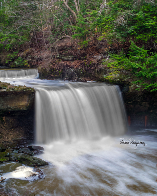
The northern section of Mill Creek Park includes Lanterman’s Falls and the Mill Creek Gorge. This area offers breathtaking views with its cascading waters, steep hillsides beautifully covered with deciduous and evergreen trees, bold sandstone outcroppings, and numerous grass-covered meadows. South of the gorge the land is rolling and partly wooded.
The northern section of Mill Creek Park includes Lanterman’s Falls and the Mill Creek Gorge. This area offers breathtaking views with its cascading waters, steep hillsides beautifully covered with deciduous and evergreen trees, bold sandstone outcroppings, and numerous grass-covered meadows. South of the gorge the land is rolling and partly wooded.


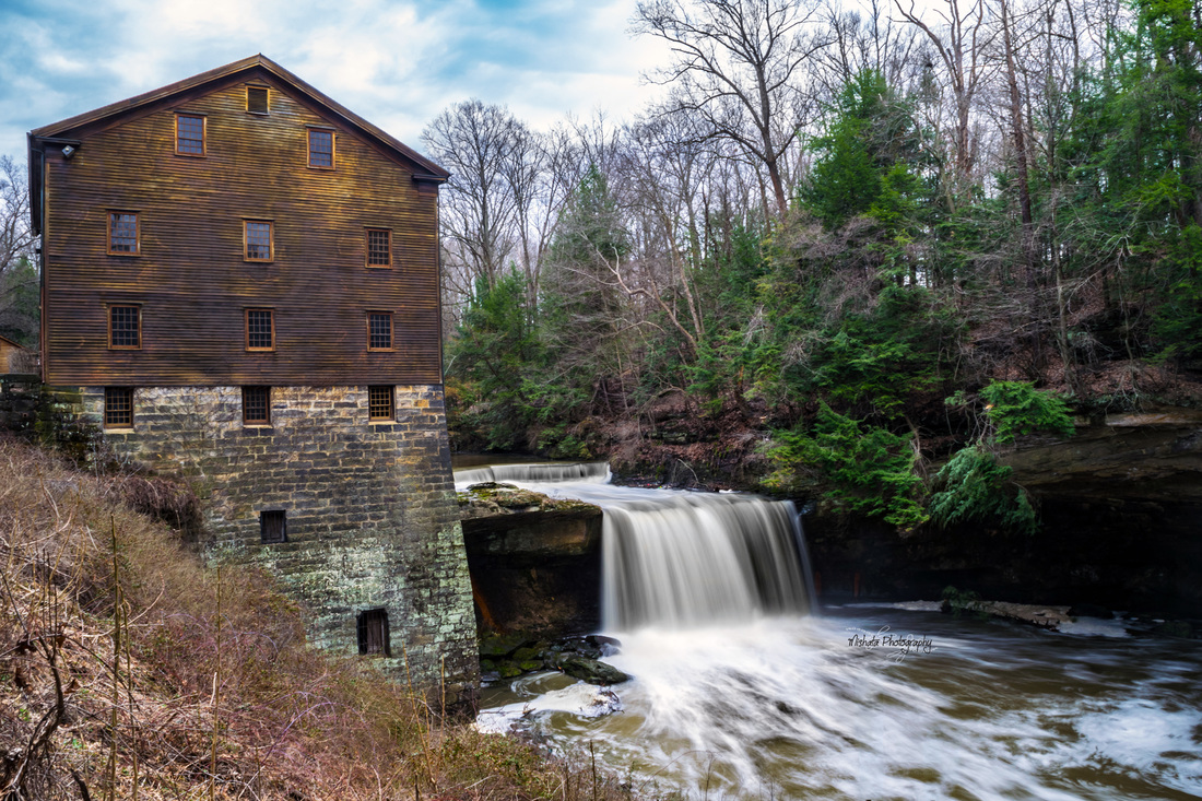
Lanterman's Mill
One of Mahoning County’s most historic landmarks, Lanterman’s Mill was built in 1845-46 by German Lanterman and Samuel Kimberly. Restored in 1982-85 through a gift from the Ward and Florence Beecher Foundations, this community treasure represents one of the many pioneer industries developed along Mill Creek and operates today as it did in the 1800s, grinding corn, wheat, and buckwheat.
Fellows Riverside Garden
Fellows Riverside GardensFellows Riverside Gardens is a free public garden located at the northern end of Mill Creek Park. This twelve-acre display garden features a landscape of remarkable beauty with diverse and colorful plant displays, roses of all classes, seasonal displays of annuals, perennials, flowering bulbs, and scenic vistas.


Leesburgh Falls, Mercer County Pa
A 50-yard walk to such a wide and impressive falls is hard to beat. The base of the falls is reached by a short scramble down a steep, muddy slope, avoiding a set of old railroad tie stairs in the process. Only 13 feet tall but more than 60 feet wide, it’s surprising how narrow Wolf Creek can fan out to fill the cascade’s entire width with such a consistent veil of water, but it does.


Shenango Lake, Sharpsville and Clark Pa
Shenango River Lake is a reservoir in the Shenango River Valley of western Pennsylvania and northeastern Ohio. Authorized by the Flood Control Acts of 1938, the lake is one of 16 flood control projects in the Pittsuburgh District designed to prevent flooding. It is a popular site among anglers and is lined by 330 campsites.
The concrete Shenango Dam was completed in 1965, at a height of 68 feet and a length of 720 feet at its crest, as a flood control project of the United States Army Corps of Engineers. The reservoir has a maximum capacity of 351,000 acre-feet, and a normal capacity of 29,920 acre-feet.
The concrete Shenango Dam was completed in 1965, at a height of 68 feet and a length of 720 feet at its crest, as a flood control project of the United States Army Corps of Engineers. The reservoir has a maximum capacity of 351,000 acre-feet, and a normal capacity of 29,920 acre-feet.


Kidds Mill Bridge, Transfer Pa
Kidd's Mills Covered Bridge Historic District is a national historic located at Pymatuning Township, Mercer County, Pennsylvania. The district includes two contributing sites and one contributing structure. The Kidd's Mills Covered Bridge is a historic wooden covered bridge built in 1868. It is rare example of a Smith Cross Truss bridge in the eastern United States. The district includes the sites of two grist mills.
It was added to the National Register of Historic Places in 1974.
It was added to the National Register of Historic Places in 1974.


McConnell's Mills
McConnells Mill State Park, in Lawrence County, encompasses 2,546 acres of the spectacular Slippery Rock Creek Gorge. Created by the draining of glacial lakes thousands of years ago, the gorge has steeps sides and the valley floor is littered with huge boulders and is a national natural landmark.
The bedrock at McConnells Mill State Park was formed over 300,000,000 years ago as layers of peat, mud and sand were compressed. This part of Pennsylvania was a coastal area at the time. The layers of bedrock were built into mountains as the continental plates shifted. The layers of bedrock had different strengths. Some of the layers eroded quickly and others eroded at a much slower pace. The various erosion rates account for the variety of geologic features at McConnells Mill State Park. The geology of the park was also heavily influenced by the glacial effects of the ice age: a large glacial lake (water that was held in place by a glacier), broke about 140,000 years ago. This break in the glacial dam caused a dramatic change in the flow of the water. The lake that had previously drained in a northward direction was now draining to the south. The drastic change in direction and very high volume of water flow created Slippery Rock Creek Gorge
The bedrock at McConnells Mill State Park was formed over 300,000,000 years ago as layers of peat, mud and sand were compressed. This part of Pennsylvania was a coastal area at the time. The layers of bedrock were built into mountains as the continental plates shifted. The layers of bedrock had different strengths. Some of the layers eroded quickly and others eroded at a much slower pace. The various erosion rates account for the variety of geologic features at McConnells Mill State Park. The geology of the park was also heavily influenced by the glacial effects of the ice age: a large glacial lake (water that was held in place by a glacier), broke about 140,000 years ago. This break in the glacial dam caused a dramatic change in the flow of the water. The lake that had previously drained in a northward direction was now draining to the south. The drastic change in direction and very high volume of water flow created Slippery Rock Creek Gorge
Alpha Falls
|
The 50-foot Alpha Falls, also known as Gardiner Falls or Spillway Falls, marks the exit of a small stream from a “hanging valley” into the deeper Slippery Rock Gorge. A hanging valley is one where the mouth of the tributary valley occurs on a cliff above a much deeper valley.
Hell's Hollow |


This trail begins at the Hells Hollow parking lot and follows and twice crosses Hell Run on its way to a limekiln and Hells Hollow Falls. Although the main trail is smooth and level, the section by the waterfall can be slippery.


